
Predicting urban growth of Arriyadh city, capital of the Kingdom of Saudi Arabia, using Markov cellular automata in TerrSet geospatial system
Altuwaijri, Hamad . 2019
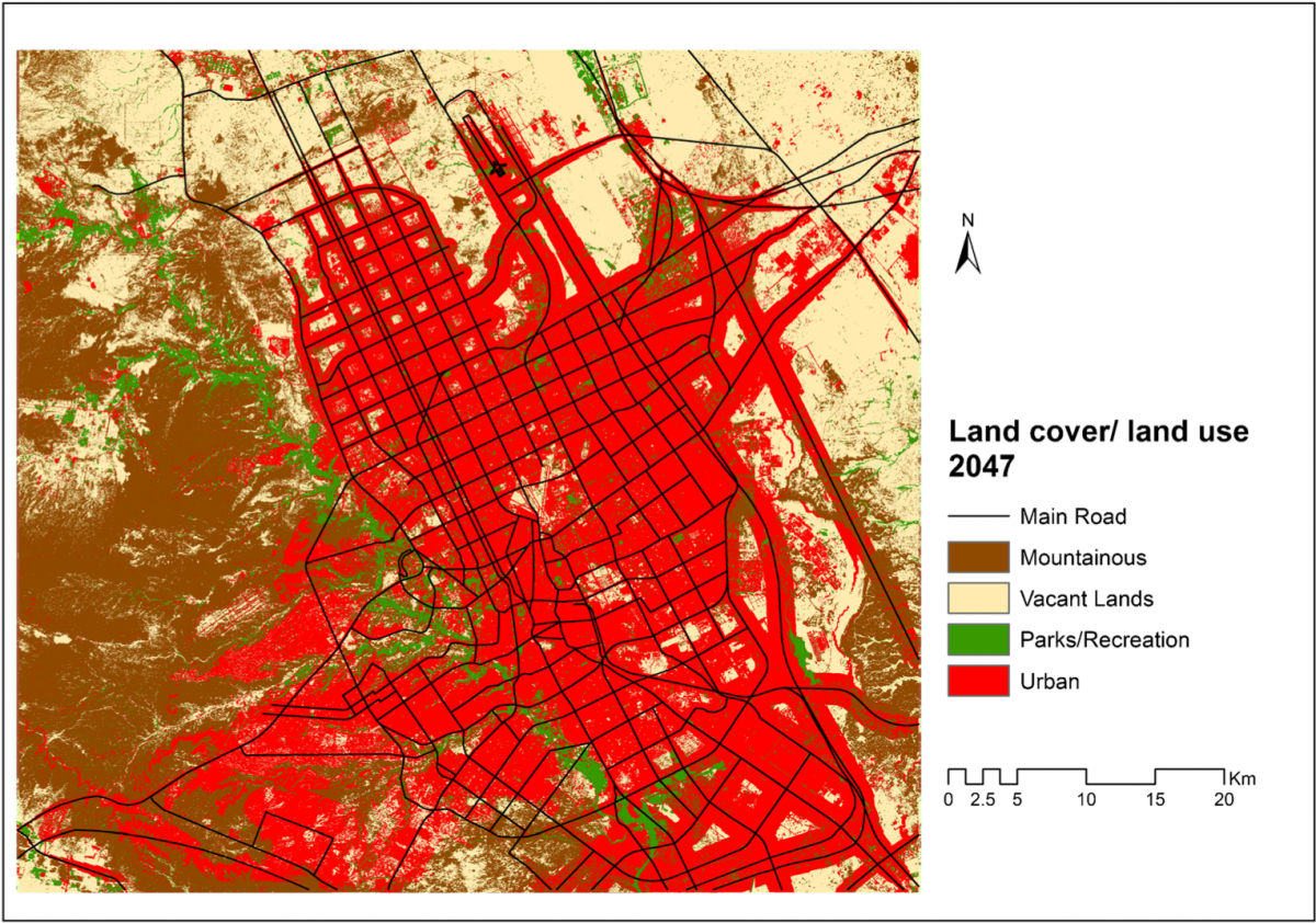
This study aimed to predict urban expansion in Arriyadh city over a 30-year period, from 2017 to 2047. In the target year 2047, several changes are expected to occur in Arriyadh. The predicting was based on the revealed outputs of urban change within the last 30-year period, from 1987 to 2017. This study aimed to clarify the extent of urban expansion that would occur in the future to compare the expected future expansion with the present expansion in the city by using spatial dimension software. Several different software programs with advanced geographic information system (GIS) and remote sensing techniques were used: for example, ArcGIS, ERDAS, and Markov cellular automata in TerrSet. Using the US Geological Survey (USGS) site, we uploaded imagery (LANDSAT) for the study period from 1987 to 2017 and used the data and information from this period as a basis for drawing conclusions for predicting the urban area in 2047; we then carried out the analysis and adjusted it, such as for classification, editing, mosaic, geometric correction, and entry of geographical factors that we saw as having an impact on the futureurban growth ofthe city. From the analysis and results drawn, the dimension of the physical changes during the 2017–2047 study period in the urban area is expected to be around 38%. The study also makes recommends using the expansion of urban studies as a tool to support decisionmakers in managing cities and to build databases to include demographic, economic, and environmental data. All this information and techniques can help in carrying out urban growth prediction accurately and clearly
 .
.

Abstract
GIS helps in visualizing and analyzing information that can help a user to monitor projects, make decisions, and develop solutions. Government agencies also use GIS to perform…
يعتبر حوض وادي بطحان أحد أهم أودية المدينة المنورة في التاثير على الحرم النبوي الشريف وذلك لوقوعه بشكل كامل من ض 2 الحوض االدنى للوادي الذي تبلغ مساحة التصريف 16.272 كم .